


The Granite Creek Bomb
Among the debris flows into the South Fork Boise River on the evening of September 12, Granite Creek is worth a look. For one reason, we said it was a ticking time bomb here and here. Secondly, the debris flow appears significant in its scale and extent.

Map highlighting the Granite Creek Watershed
First, the map above shows the watershed is about halfway between the Cow Creek bridge and the Danskin Bridge. Granite Creek is a tiny little thing with average flows in the winter months of a couple of cubic feet per second. In the spring there could be 10 to 20 cfs in the stream, based on a statistical report. All of this fits in a culvert under the South Fork road with a pipe of 36 inches in diameter.
We know from the 1978 study of the South Fork and tributaries that Granite Creek did have some documented spawning in it. In more recent years the culvert is considered an impediment to aquatic organism passage. Attempts to assess the culvert’s outflow were frustrated by too thick vegetation and steep slopes off the South Fork road.

The Google Earth view of Granite Creek watershed.
There is (or was) some forested sections in the Granite Creek watershed, primarily on the north facing slopes. It is approximately 3.5 square miles in size.
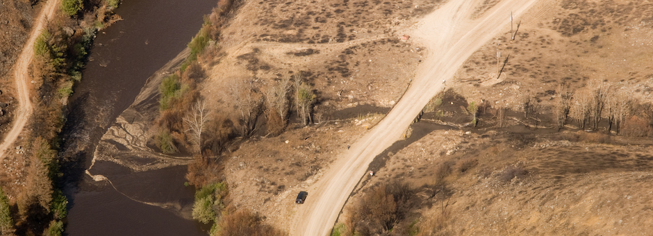
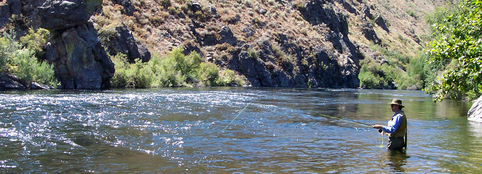
The photo from the air on Friday the 13th is dramatic:

South Fork Boise River and Granite Creek debris flow. Courtesy USDA Forest Service.
First, the debris flow overtopped the South Fork road as the little culvert was either plugged or overwhelmed. The debris fan extends well downstream as indicated by the tan or lighter-colored area in the South Fork Boise River, when compared to the chocolate color of the river upstream and on river left as it routes around the debris flow.
Another shocker is from the photo below using the Google Earth image generally in alignment with the above photo taken on Friday:

Google Earth angled image of Granite Creek confluence with South Fork Boise River
Both photos show a river flowing at 600 cfs as the Google Earth flyover was August 29, 2011. The debris flow as apparently covered the Rock Garden section of the South Fork, burying that stretch of pocket water just as it enters the Pine Tree Hole.
More amazing is the amount of water backed up with the mud and debris deposited in the river. The water is backed up and at a much higher elevation, so much at the willows and other stream side bushes are inundated, surrounded by muddy waters. This is most apparent along the left bank. At the bottom of the slope the group of trees appears in water too! The water elevation appears to be 2-3 feet higher than normal.
This condition will not last as the river will continue to cut a channel through the debris and the smaller size material (silt and sand) will be carried downstream. That Pine Tree Hole is going to be full of material for some time.
How fast the river cuts a channel and clears out the smaller material is going to be affected by how much flow is in the river. The winter time flows of 300 cfs commence on September 16, so what ever energy the river has to move the material downstream will be greatly reduced.
A natural follow-on question is the effect of this and the other debris flows on the South Fork Boise River fishery. This is a question much more difficult to determine at this time. The extent of the numerous locations where flows entered the river and apparently blocks flows on Thursday the 12th must be considered in a cumulative fashion. A full accounting of the flows and estimates of each disturbance event would be a good first step.
A further consideration is that while fish populations can be affected by these type of disturbances and recover over time, the cumulative effect of several debris flows into a river that has a controlled flow release regime could mean the recovery of the river will be dependent on how the water releases are managed in the spring and summer months. For example, could artificial spring freshets be managed in order to help move sediment through the river system? This is a topic that conservation and angler groups will need to work with the government agencies and other affected water users.
RAIN CHANGES EVERYTHING: Mudflows in South Fork Canyon blocks road, inundates river, closure continues
So much for that plan to open a portion of the South Fork Boise River.
The email message from the Boise National Forest’s Mountain Home Ranger District:
Guys, due to the mudslides and ongoing instability of the area, the SF Boise River will NOT open as discussed at the TU meeting Wednesday. The area will remain closed until further notice. As of now all access roads to the SF are closed. Again the area is closed to everyone except Federal, State or County personnel in performance of official duty.
The rain gage at Anderson Ranch Dam recorded more than 0.6 inches of precipitation on Thursday evening September 12. This piece of data portended the mudslides, gullywashers and mass failures that have inundated the South Fork Boise road and reached the river in many locations. For example the photo below from KTVB.com shows a big mudslide.

Mud slide across South Fork Boise road just east of Reclamation Village. Photo from KTVB.com website
News coverage with some photos can be found at the Idaho Statesman and at KTVB websites. There is also a very good overview news release from the Boise National Forest here.
Fire Effects Discussed; Partial Opening of River Imminent; Stranding Study Slated September Sixteenth

Good attendance for community meeting on South Fork Boise River
Approximately 75 people made it to the MK Nature Center Wednesday Night to get the low down on the effects of the wildfire that affected the South Fork Boise River. The audience got a dose of information where things stand with the South Fork.
Mountain Home District Ranger Stephaney Church said she is working to open the section of the South Fork of the Boise River from the Cow Creek bridge downstream. Perhaps as soon as this weekend.
Church said the section of the river was less affected than from Anderson Ranch Dam to Cow Creek. This website back on August 21 showed the extent of the fire in the lower section of the river. There were fewer trees burned along the river and therefore less work to be done to cut down the trees that could be a safety hazard. Further upstream its a different story and it will take much longer to assess the safety hazards and do something about them.
One questioner missed badly when stating that everyone attended the meeting just because they want to know when the river will be open again to fish. Visits to this website and discussions among the fishing and conservation groups show otherwise, as there is significant interest in the long-term future for the South Fork fishery and for the river ecosystem.

Dick Frencer of Boise Valley Fly Fishers poses a question to Stephaney Church
Agency staff with the Forest Service, BLM and Idaho Fish and Game described the effects of the fire and the field assessments done so far so a game plan can be developed to address the most immediate needs for emergency rehabilitation. While the meeting discussion was at a more general level, some specifics have emerged. For example, the Elk Complex fire north of the river experienced much severe burning and the effects on soils in some locations appears fairly dramatic. We are keeping an eye on Pierce Creek, Granite Creek and Rough Creek. All three drain into the South Fork of the Boise from the north side. Granite Creek in particular could be a ticking time bomb with a small culvert and a watershed that appears to have seen severe fire effects. Pierce Creek of course no longer has a small culvert but rather a new bridge, so if there is a gully washer one hopes the flows and debris should be able to pass under the bridge.
Meanwhile the stranding study will proceed with government agency staff biologists on Monday, September 16 when the South Fork Boise River flows will drop to 300 cfs. Idaho Fish and Game and the Bureau of Reclamation will have staff on site to ascertain the amount of stranding when the river flows are cut. This information will help inform future management changes with river flows.
South Fork Boise Community Meeting September 11th
In the wake of the Pony Complex and Elk Complex Fires and their destruction of substantial habitat along the South Fork of the Boise River downstream of Anderson Ranch Dam, the Ted Trueblood Chapter of Trout Unlimited is organizing a meeting to serve as an open forum for all those concerned at 7:00 p.m. on Wednesday, September 11th, 2013 at the MK Nature Center.

Rock garden and Pine Tree Hole
We believe that it is essential that we work in collaboration and cooperation with our government agency partners in a supporting role. In our view, once they determine the strategy/way forward, priorities of work and requirements, we can then mobilize our constituents and resources to help.
There remain a lot of unknowns and we understand that the assessment of the extent of the damage will not be complete for a number of weeks. As an initial step by those of us in the community, this open forum meeting will include agency representatives to provide information on the post-fire habitat condition of the South Fork of the Boise River. It will provide the opportunity to discuss where we are today, where we think we are going, what we think is needed, and how we might help.