South Fork Recovery Begins with You November 9th

Make plans for Saturday November 9th for volunteer planting along the South Fork Boise River to kick start the recovery of the river corridor from the recent wildfire and mud flow events.

The plan is to meet at the parking lot near Albertsons near Federal Way and Gowen Road (next to Exit 57 on I-84) at 8:30 a.m. We will organize those who want to car pool and to leave promptly at 9:00 a.m. for the drive to the South Fork of the Boise.

Thanks to the more than four dozen people who signed up to volunteer at the September 11 meeting we think we will have a core group to start.  But additional help is needed for this effort.  We are working to get the word out with the fly shops and the fishing clubs.  The Boise National Forest is determining what plants and trees will be planted, they types and quantities. Needed tools are being identified.  At this time we need you to sign up to help. You can call Bob Caldwell at (208) 322-5539 and leave a message or email BandDCaldwell@gmail.com.

There are several areas where the debris flows scoured the gound the removed vegetation.  These areas will be one to plant.  Other sites where the fire burned may also need planting, but in many cases we are already seeing willow begin to regenerate on its own from the roots that were not killed in the fire.

Knowing in advance how many people are coming will help planners determine how much we can get done.  Lunch will be provided on site.  And, there is not Boise State football game on November 9th so don’t worry about that potential conflict.

Shutdown stalls South Fork recovery activities

The Federal government shutdown that started October 1 has thwarted any movement towards long-term recovery of the South Fork Boise River.  And any decisions about opening the river or a portion thereof to fishing has also been stymied.

While so-called “essential” staff are still on the job (without pay), which includes fire, law enforcement and burned area emergency rehabilitation activities, other Federal government professionals are not.

Deep-rooted cottonwoods like those in the tub at Lucky Peak Nursery are available for planting. L to R: Matt Perkins, City of Boise nursery; John Sloan, Lucky Peak Nursery; Pam Harrington, Trout Unlimited; Clark Fleege, Lucky Peak Nursery

Discussions in late September identified the potential for planting cottonwoods in some areas along the South Fork Boise River.  Cottonwood cuttings taken from South Fork Boise River have been growing at the Boise National Forest Lucky Peak Nursery, and several dozen of these trees could go in the ground before the snow flies to begin the long-term recovery effort for the South Fork.  The meeting to decide when, where and what to plant would have happened October 1st or 2nd, but the government shutdown slammed the door on this little initiative.

Conservation groups had approached the Boise National Forest about the  idea to do some planting along the South Fork.  The Forest is very interested in using some volunteers and have identified some areas where planting can do some good, and where it would be safe to have volunteers do some work.  Not only that, the cottonwood trees are at Lucky Peak Nursery, ready to be put in the ground.  But until the government shutdown is over little can be done about it.

Granite Creek blowout washed away the hill side. Perhaps a good location for some cottonwood trees?

Once the shutdown is over and some progress gets made on a planting project we will provide an update at this website.


The 2013 Weak Water Year

We grabbed a few charts at the end of Water Year 2013 to put some perspective on the water situation.

Flows from Anderson Ranch Dam:

Flow From Anderson Ranch Dam where blue line = 2013, green line = 2012, red line = long-term average

The summertime flows were 1,600 cfs instead of 1,800 cfs in 2012.  The 1,600 cfs flows extended well into August to provide irrigation water to users in the Treasure Valley.  The rest of the system was draining so more water was moved from Anderson Ranch pool.  And you can see what happened in the reservoir here:

Water stored in Anderson Ranch Dam blue line is 2013 and green line 2012 and long term average is the red line

Anderson Ranch reservoir started the water year (October 2012) very near the average for water in the pool.  The low snowpack in the winter meant less runoff into the pool in the spring and early summer.  The peak amount of water in May was nowhere near the average, let alone filling Anderson Ranch.  The the 1,600 cfs flows pulled the contents to an amount well below average and at a high rate until mid August.  The water year ends with 100,000 acre feet in the pool.

The reservoir drained very quickly because it was a year where much less water flowed into Anderson Ranch Reservoir as seen in the chart for the water gage at Featherville:

Water flows on South Fork at Featherville gage with 2013 in blue, 2012 in green and average in red

So the blue line in the chart above shows just how below average the flows were upstream of Anderson Ranch pool.  By the way, the spike in river flows in late April 2012 on the green line is a same time when a record flow was observed in the Middle Fork Boise River at Twin Springs gage.  Some readers may recall the late April heavy rains that  melted much of the lower to mid elevation snow into the South Fork Boise River.

One indication of the water year ending in a whimper is what happened with the flow gage on the South Fork Boise a mile or so downstream of Anderson Ranch Dam:

River flow data in late September 2013 was affected by the landslides into the South Fork Boise

The slides on September 12, 2013 knocked out the water gages for a few days.  They are back running now, but the chart above from September 24 shows only a brief period when it was working that day and no data was charted for previous days.  This situation is understandable given that much debris tumbled into the South Fork and it may have directly affected the functioning of the gage or perhaps changed the profile of the channel in the area of the gage making a clean reading of water flows a challenge and thus a need to recalibrate the equipment.  The automated system for this gage is working as shown on the USGS gage here.

Looking forward, there have been some inquiries and informal discussion whether it would be possible to shape flows from Anderson Ranch Dam in 2014 to deal with the debris and sediment in the South Fork Boise River to help transport the sediment and allow the river to carve a channel through the massive deposits in the river.  For any of this to happen it will require water in Anderson Ranch pool that is not yet there.  A winter with above average snow could be very important to developing some alternatives to shape the flow releases, their timing and magnitude, and it will have to happen without adverse effects on downstream water users.  But readers may be interested in knowing it is a topic of conversation, or at least was prior to the government shutdown.


Tagged ,

AS DESIGNED: Pierce Creek Bridge Weathers the Storm

Pierce Creek bridge on September 13

Longer-term visitors to this website may recall seeing stories when the Pierce Creek Reconnection Project started and completed and the role tributaries play in maintaining a fishery.

The mud and debris flows from Pierce Creek on September 12th were both substantial in amount delivered to the South Fork of the Boise River and unique in that the entire flows went under the bridge.

This was by design because when the project went forward in 2011 project engineers used data on the high flow estimates for Pierce Creek.  And while not to spike the ball in the end zone or anything, it is satisfying to see something perform pretty much as planned.

But the story is not over.  There could be more weather events that cause more flooding with a similar mud slurry.  And there are lasting effects from the September 12 event that will need repair to the stream channel.

While the slurry was confined to under the bridge many of the grade control structures in the channel were swept into the river.  Here is how the channel looks today:

Looking downstream from Pierce Creek bridge September 16, 2013

Many boulders are covered in mud but many are also now in the South Fork of the Boise River.  A large drop in the stream bed as seen in the foreground (bottom of the photo) did hold in place as that large boulder is part of the channel that was in place prior to the removal of the culvert in 2011.  The vertical drop creates a barrier to fish wanting to move upstream.

Compare the above photo with that from early 2012 just prior to planting the site:

Early spring 2012 showing the step pools in Pierce Creek

The right bank of Pierce Creek through the trees was scoured of nearly all the brushy vegetation, brush that is clearly visible in the 2012 photo.  Meanwhile the plantings on the left bank are still in place after the mud flows.

So work will be done to shore up the grade control of the stream and make it possible for fish to be able to move freely upstream and downstream in Pierce Creek.  Thanks to a generous donation of time from Quadrant Consulting the field survey work will commence later this week.  We salute Quadrant’s contribution to the South Fork fishery!  As survey work transitions to construction we will provide updates.

Layman’s Guide to South Fork Landslides

With the number of slides that occurred from the rain on September 12 we thought it would be useful to provide a primer on the six slides that have been documented.  Many of the photos came from different news sources and government agencies.  Not all photos were specifically located so a field recon on Monday aided in getting a sense of what happened last week.

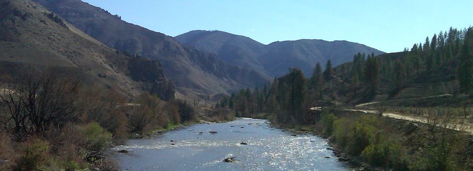
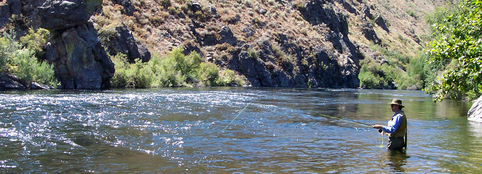
A couple of things first: the road is closed from Highway 20 to the Anderson Ranch Dam and down along the South Fork Boise.  The road from Highway 20 to Cow Creek bridge is open, and continues to be open downstream to Prairie and beyond.  Upstream of Cow Creek bridge the road is closed (as of September 17).  Second, the water is murky in the South Fork not only because of the mud flows and land slides that reached the river, but also because of the turbidity in the water coming out of Anderson Ranch Dam.  There is a lot of silt that is in suspension in the reservoir.

Each slide is presented in order starting upstream and working in a downstream direction.

1. Approximately one mile downstream of Anderson Ranch Dam you reach the boat ramp (a.k.a. Tailwaters) and you see the first landslide:

Landslide downstream of boat ramp. Photo from KTVB

Mud and debris plugged the side channel on river right and created a rapid which currently has some snags.  Navigation could be a problem until the trees are washed down or removed.  The side channel will not return unless higher flows scour the channel.  The slide also put enough material in the river to raise the water elevation and create a slow water area, probably a couple of hundred yards in length, upstream of the slide.  It is similar to what anglers and boaters have experienced upstream Rough Creek since the landslide in January 1996.

2. Downstream a few hundred feet there is a separate slide that appears to have delivered less volume to the river, but nonetheless put a lot of mud and debris on the road.

Second mudslide is just downstream of the first one. Photo by John Wirt, US Geological Survey

Some anglers refer to this general area as the Owl Rock Hole.  The rock outcrop partially obscures the river when the photos are from the road, high above the river.

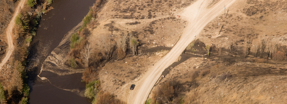
3.  Just east of Reclamation Village a slide covered some 700 feet of road with mud.

Mud slide east of Reclamation Village. Photo from Boise National Forest

Approximately 3,000 cubic yards of material will have to be removed from the road.  The photo indicates much more than that crossed the road, much of which entered the South Fork.

The photo below is another angle and shows the Anderson bridge upstream of the slide as well as how far across the river the slide reached.

Mud slide at Reclamation Village puts the squeeze on the River

Some anglers will remember on the south side of the river the large rock outcrop with a deep hole below it.  Wherein lurk some large trout.  The early report is the deep pool appears to be more of a run than a pool.  And the photo does appear to show a some mud across the river at the subsurface.

4. From Reclamation Village it is approximately 4.5 miles downstream to the confluence with Rough Creek.  There may be slides between these two points but no identifying photographs have been produced.  And the road is closed in this reach so any field recon effort is not possible.

Rough Creek and South Fork Boise River road

At Rough Creek a major slide pushed across the road, covered much of the slide area of 1996 and dropped into the river.  It appears the 2013 edition of the Rough Creek slide is different than the 1996 event, at least from the photographs and inspection of other slides.  The new one resulted from the rain after fire removed nearly all vegetation in the catchment.  There is a lot of sand and silts in the mud, and some coarse material typical of the Idaho batholith.  The slide in January 1996 was very different because it had more evidence of a mass failure dominated by large sized rubble and boulders moving into the river.

View looking downstream with Rough Creek slide coming from the right.

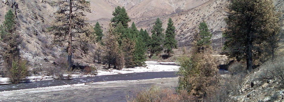
The extent of the mud flow versus the water is evident in the above photo.  Much of the profile line of the mud flow approximates the slide from 1996.  It appears that the amount of debris on this slide was relatively less than at Reclamation Village. The slide area and rapid is a confined river channel thanks to the rubble that remains from 1996 and the water velocities are relatively higher in this area.  Even at the 600 cfs flows as in the photo above there is already a demarcation between the river flow and the mud flow.

5.  The big debris flow occurred at Granite Creek.  We already provided some background on this blowout.   If anything, the scale of the event was underestimated.

South Fork Boise River and Granite Creek debris flow. Courtesy USDA Forest Service.

The photo at left shows the debris fan well into the river and then it appears to taper off to river right along a 500 foot length of channel.  Secondly, there is significant change to the backwater created by the mudflow as the river banks are flooded and the river much wider.  The streamside willows are now nearly in the middle of the river!

What the photo does not show is the extent of the debris that washed downstream around the bend in the river.  The Rock Garden is completely covered. The Pine Tree Hole is no more.  The hole filled with mud and debris and now has a fast moving riffle cutting through the deposit.

This is where the Rock Garden used to transition into the Pine Tree Hole. Note the large tree on the new gravel bar.

In the photograph above and island could form from the gravel bar if high flows do not move the tree.  Vegetation can establish and stabilize the deposit. 

For nearly one-half mile – from Granite Creek around the bend – the river takes on a series of S curves, as illustrated in the photo below.

View upstream at what once was the Rock Garden

This new channel is cutting through the mud flow and will continue to change the form of the stream as there is no stream side vegetation to stabilize the banks.  And it appears much of the material may be appropriate sized gravel suitable for spawning, assuming the smaller sands and silts can be washed away.  Concerns about a lack of spawning habitat in the main river may have been addressed.

Around the bend, downstream of what used to be the Pine Tree Hole

One takeaway from seeing the extent of the mud slide from Granite Creek is that anglers will need to be aware of safety hazards associated with the relatively loose material deposited along the stream bottom as well as the significant amount of trees and associated debris.

One gravel bar made up of material from Granite Creek is nearly one-half mile downstream.  The Granite Creek bomb slide event appears to have won the prize for affecting the most area along the river.

6. The final mud flow and slide is at Pierce Creek, and there is some good news here.  When the Forest Service initially circulated aerial photos of the mud slides across the road and into the river Pierce Creek was not included.  This is because the new bridge at Pierce Creek was designed and built to pass more water under it.  And it worked.  And because it worked there was little in the photograph to see, at least across the road.

The mud in Pierce Creek went under the bridge.

It appears the slide from Pierce Creek is on the scale with Rough Creek, neither being as large as Granite Creek.  But still significant nonetheless.

The bridge was constructed in 2011 as a cooperative project with a number conservation groups and agencies to reconnect Pierce Creek so trout from the South Fork Boise River could access it.  A four foot dimeter culvert was replaced with a bridge with a much larger opening that in this instance was able to pass the mud flows and debris into the river.

Much of the grade control structure of Pierce Creek downstream of the bridge was blown out.

One effect from the magnitude and character of the mud flow was its impact on Pierce Creek.  Much of the rock placed in the simulated channel was washed out and this will need to be replaced so that fish passage can be restored.  The photo above shows the rock on one bank was either scoured away or covered with mud.  On the other side of Pierce Creek some of the vegetation appears much less affected.  Some very large foundation rocks in the stream bottom held in place as the waterfall is evidence of the loss of a more gradual step pool channel.

So that’s it for where the slides occurred and what they look like.  It’s way to early to know what this all means for the South Fork Boise River.  Much clean up and repair is occurring.  Rehabilitation of the burned areas will commence this fall and mulching and seeding activities will help the land recover and stabilize so these type of events will be less likey to happen in the future.